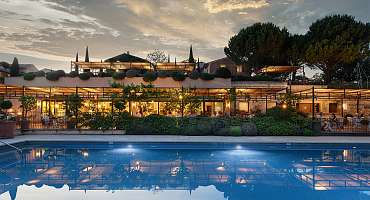
Au cœur d'une exploitation oenotouristique, séjournez à l'hôtel Coquillade Provence. Un lieu tout confort pour découvrir les Ocres à vélo.
mis à jour le 31/03/2023 par Velo Loisir Provence
Entre vignes et champs de lavande dans un décor enchanteur, profitez des nombreux services qu'offre le resort : Spa, piscine,restaurants, wellness center, cycling center..
Un véritable havre de paix au coeur de la nature qui saura satisfaire toutes vos envies et vous permettra de découvrir à vélo les joyaux du Luberon.
Du 20/02 au 31/12/2024.
Chambre double : à partir de 580 € (Tarif incluant petit-déjeuner, minibar et accès spa)
Equipements
Services
Conforts
Langues parlées
Mode de paiement
Galerie photos
array(1) {
["gpx"]=>
array(30) {
[0]=>
array(12) {
["id_Gpx"]=>
string(3) "344"
["id_Objet"]=>
string(3) "366"
["idPage"]=>
string(4) "1241"
["idLangue"]=>
string(1) "3"
["title"]=>
string(68) "GTV MTB Etappe 8 - Von Vitrolles-en-Luberon bis Lauris - Luberon MTB"
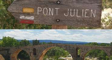
["ancre"]=>
string(51) "GTV VTT Etape 8 - De Vitrolles-en-Luberon à Lauris"
["idImage"]=>
string(4) "1198"
["latitude"]=>
string(7) "5.58194"
["longitude"]=>
string(7) "43.8289"
["description"]=>
string(182) "Rund um den Mourre Nègre, dem höchsten Punkt des Luberon NRP, ist diese Strecke ein Genuss für diejenigen, die über den Körperbau und die Technik verfügen, um sie zu schätzen."
["url"]=>
string(71) "/page/gtv-vtt-etape-8---de-vitrolles-en-luberon-a-lauris---de+1241.html"
["colorGPX"]=>
string(7) "#ce4986"
}
[1]=>
array(12) {
["id_Gpx"]=>
string(3) "344"
["id_Objet"]=>
string(3) "366"
["idPage"]=>
string(4) "1240"
["idLangue"]=>
string(1) "2"
["title"]=>
string(67) "GTV MTB Stage 8 - From Vitrolles-en-Luberon to Lauris - Luberon MTB"
["ancre"]=>
string(51) "GTV VTT Etape 8 - De Vitrolles-en-Luberon à Lauris"
["idImage"]=>
string(4) "1198"
["latitude"]=>
string(7) "5.58194"
["longitude"]=>
string(7) "43.8289"
["description"]=>
string(159) "Around the Mourre Nègre, the highest point of the Luberon PNR, this stretch is a treat for those who will have the physics and the technique to appreciate it."
["url"]=>
string(71) "/page/gtv-vtt-etape-8---de-vitrolles-en-luberon-a-lauris---en+1240.html"
["colorGPX"]=>
string(7) "#ce4986"
}
[2]=>
array(12) {
["id_Gpx"]=>
string(3) "344"
["id_Objet"]=>
string(3) "366"
["idPage"]=>
string(4) "1239"
["idLangue"]=>
string(1) "1"
["title"]=>
string(65) "GTV VTT Etape 8 - De Vitrolles-en-Luberon à Lauris - Luberon VTT"
["ancre"]=>
string(51) "GTV VTT Etape 8 - De Vitrolles-en-Luberon à Lauris"
["idImage"]=>
string(4) "1198"
["latitude"]=>
string(7) "5.58194"
["longitude"]=>
string(7) "43.8289"
["description"]=>
string(174) "Autour du Mourre Nègre, point culminant du PNR du Luberon, ce tronçon se révèle un régal, pour celles et ceux qui auront le physique et la technique pour l’apprécier."
["url"]=>
string(40) "/page/gtv-vtt-etape-8-vitrolles-a-lauris"
["colorGPX"]=>
string(7) "#ce4986"
}
[3]=>
array(12) {
["id_Gpx"]=>
string(3) "338"
["id_Objet"]=>
string(3) "467"
["idPage"]=>
string(4) "1545"
["idLangue"]=>
string(1) "1"
["title"]=>
string(64) "GTV VTT Etape 5 - De St-Saturnin-les-Apt à Fontaine-de-Vaucluse"
["ancre"]=>
string(67) "GTV VTT Etape 5 - De Saint-Saturnin-les-Apt à Fontaine-de-Vaucluse"
["idImage"]=>
string(4) "1203"
["latitude"]=>
string(7) "5.38198"
["longitude"]=>
string(7) "43.9425"
["description"]=>
string(156) "A partir de Saint-Saturnin-lès-Apt, vous rejoignez rapidement par des sentiers VTT, entre vignes et vergers, la bucolique Combe de Font Jouval. Un régal !"
["url"]=>
string(70) "/page/gtv-vtt-etape-5-de-saint-saturnin-les-apt-a-fontaine-de-vaucluse"
["colorGPX"]=>
string(7) "#7e6355"
}
[4]=>
array(12) {
["id_Gpx"]=>
string(3) "338"
["id_Objet"]=>
string(3) "467"
["idPage"]=>
string(4) "1546"
["idLangue"]=>
string(1) "2"
["title"]=>
string(66) "GTV MTB Stage 5 - From St-Saturnin-les-Apt to Fontaine-de-Vaucluse"
["ancre"]=>
string(67) "GTV VTT Etape 5 - De Saint-Saturnin-les-Apt à Fontaine-de-Vaucluse"
["idImage"]=>
string(4) "1203"
["latitude"]=>
string(7) "5.38198"
["longitude"]=>
string(7) "43.9425"
["description"]=>
string(147) "From Saint-Saturnin-lès-Apt, you quickly reach by mountain bike trails, between vineyards and orchards, the bucolic Combe de Font Jouval. A treat!"
["url"]=>
string(87) "/page/gtv-vtt-etape-5---de-saint-saturnin-les-apt-a-fontaine-de-vaucluse---en+1546.html"
["colorGPX"]=>
string(7) "#7e6355"
}
[5]=>
array(12) {
["id_Gpx"]=>
string(3) "338"
["id_Objet"]=>
string(3) "467"
["idPage"]=>
string(4) "1547"
["idLangue"]=>
string(1) "3"
["title"]=>
string(67) "GTV MTB Etappe 5 - Von St-Saturnin-les-Apt bis Fontaine-de-Vaucluse"
["ancre"]=>
string(67) "GTV VTT Etape 5 - De Saint-Saturnin-les-Apt à Fontaine-de-Vaucluse"
["idImage"]=>
string(4) "1203"
["latitude"]=>
string(7) "5.38198"
["longitude"]=>
string(7) "43.9425"
["description"]=>
string(166) "Von Saint-Saturnin-lès-Apt aus erreichen Sie schnell über Mountainbike-Strecken zwischen Weinbergen und Obstgärten die idyllische Combe de Font Jouval. Ein Genuss!"
["url"]=>
string(87) "/page/gtv-vtt-etape-5---de-saint-saturnin-les-apt-a-fontaine-de-vaucluse---de+1547.html"
["colorGPX"]=>
string(7) "#7e6355"
}
[6]=>
array(12) {
["id_Gpx"]=>
string(5) "14431"
["id_Objet"]=>
string(4) "3833"
["idPage"]=>
string(5) "11750"
["idLangue"]=>
string(1) "1"
["title"]=>
string(55) "Itinéraire Gravel Luberon n°17 - Au pays des Ayguiers"
["ancre"]=>
string(47) "Itinéraire Gravel n°17 - Au pays des Ayguiers"
["idImage"]=>
string(5) "12264"
["latitude"]=>
string(7) "5.38215"
["longitude"]=>
string(7) "43.9415"
["description"]=>
string(151) "L’itinéraire Au pays des Ayguiers est fait pour vous ! Ce parcours technique avec de forte ascensions vous fera traverser l’histoire du Vaucluse !"
["url"]=>
string(61) "/page/itineraire-gravel-n17---au-pays-des-ayguiers+11750.html"
["colorGPX"]=>
string(7) "#3388ff"
}
[7]=>
array(12) {
["id_Gpx"]=>
string(5) "14431"
["id_Objet"]=>
string(4) "3833"
["idPage"]=>
string(5) "11751"
["idLangue"]=>
string(1) "2"
["title"]=>
string(52) "Itinéraire Gravel n°17 - Au pays des Ayguiers - EN"
["ancre"]=>
string(52) "Itinéraire Gravel n°17 - Au pays des Ayguiers - EN"
["idImage"]=>
string(5) "12264"
["latitude"]=>
string(7) "5.38215"
["longitude"]=>
string(7) "43.9415"
["description"]=>
string(196) "Are you a Gravel enthusiast? The Au pays des Ayguiers route is for you! This technical route, with its steep climbs, will take you through the history of the Vaucluse! Between forests and castles!"
["url"]=>
string(66) "/page/itineraire-gravel-n17---au-pays-des-ayguiers---en+11751.html"
["colorGPX"]=>
string(7) "#3388ff"
}
[8]=>
array(12) {
["id_Gpx"]=>
string(5) "14431"
["id_Objet"]=>
string(4) "3833"
["idPage"]=>
string(5) "11752"
["idLangue"]=>
string(1) "3"
["title"]=>
string(52) "Itinéraire Gravel n°17 - Au pays des Ayguiers - DE"
["ancre"]=>
string(52) "Itinéraire Gravel n°17 - Au pays des Ayguiers - DE"
["idImage"]=>
string(5) "12264"
["latitude"]=>
string(7) "5.38215"
["longitude"]=>
string(7) "43.9415"
["description"]=>
string(0) ""
["url"]=>
string(66) "/page/itineraire-gravel-n17---au-pays-des-ayguiers---de+11752.html"
["colorGPX"]=>
string(7) "#3388ff"
}
[9]=>
array(12) {
["id_Gpx"]=>
string(5) "14430"
["id_Objet"]=>
string(4) "3832"
["idPage"]=>
string(5) "11747"
["idLangue"]=>
string(1) "1"
["title"]=>
string(67) "Itinéraire Gravel Luberon n°18 - Entre ocres, vignes et garrigues"
["ancre"]=>
string(59) "Itinéraire Gravel n°18 - Entre ocres, vignes et garrigues"
["idImage"]=>
string(5) "12263"
["latitude"]=>
string(7) "5.37602"
["longitude"]=>
string(7) "43.8789"
["description"]=>
string(181) "Vous souhaitez découvrir la pratique du Gravel ? Partez sur l’itinéraire Entre Ocres, Vignes et Garrigues. Une boucle de 40km à réaliser à votre rythme et sans difficultés !"
["url"]=>
string(73) "/page/itineraire-gravel-n18---entre-ocres--vignes-et-garrigues+11747.html"
["colorGPX"]=>
string(7) "#3388ff"
}
[10]=>
array(12) {
["id_Gpx"]=>
string(5) "14430"
["id_Objet"]=>
string(4) "3832"
["idPage"]=>
string(5) "11748"
["idLangue"]=>
string(1) "2"
["title"]=>
string(64) "Itinéraire Gravel n°18 - Entre ocres, vignes et garrigues - EN"
["ancre"]=>
string(64) "Itinéraire Gravel n°18 - Entre ocres, vignes et garrigues - EN"
["idImage"]=>
string(5) "20133"
["latitude"]=>
string(7) "5.37602"
["longitude"]=>
string(7) "43.8789"
["description"]=>
string(251) "Would you like to discover gravel riding? Set off on the Entre Ocres, Vignes et Garrigues route. A 40km loop to be completed at your own pace and without difficulty! Starting from Apt, you'll wind your way through the splendid villages of the Luberon!"
["url"]=>
string(78) "/page/itineraire-gravel-n18---entre-ocres--vignes-et-garrigues---en+11748.html"
["colorGPX"]=>
string(7) "#3388ff"
}
[11]=>
array(12) {
["id_Gpx"]=>
string(5) "14430"
["id_Objet"]=>
string(4) "3832"
["idPage"]=>
string(5) "11749"
["idLangue"]=>
string(1) "3"
["title"]=>
string(64) "Itinéraire Gravel n°18 - Entre ocres, vignes et garrigues - DE"
["ancre"]=>
string(64) "Itinéraire Gravel n°18 - Entre ocres, vignes et garrigues - DE"
["idImage"]=>
string(5) "20133"
["latitude"]=>
string(7) "5.37602"
["longitude"]=>
string(7) "43.8789"
["description"]=>
string(0) ""
["url"]=>
string(78) "/page/itineraire-gravel-n18---entre-ocres--vignes-et-garrigues---de+11749.html"
["colorGPX"]=>
string(7) "#3388ff"
}
[12]=>
array(12) {
["id_Gpx"]=>
string(5) "14429"
["id_Objet"]=>
string(4) "3831"
["idPage"]=>
string(5) "11744"
["idLangue"]=>
string(1) "1"
["title"]=>
string(55) "Itinéraire Gravel Luberon n°19 - Les Ocres du Luberon"
["ancre"]=>
string(47) "Itinéraire Gravel n°19 - Les Ocres du Luberon"
["idImage"]=>
string(5) "11190"
["latitude"]=>
string(7) "5.37602"
["longitude"]=>
string(7) "43.8789"
["description"]=>
string(166) "Entre sensation et point de vue, mettez-vous en selle sur l’itinéraire gravel « Les Ocres du Luberon » ! C’est LE parcours idéal pour les amateurs de gravel !"
["url"]=>
string(61) "/page/itineraire-gravel-n19---les-ocres-du-luberon+11744.html"
["colorGPX"]=>
string(7) "#3388ff"
}
[13]=>
array(12) {
["id_Gpx"]=>
string(5) "14429"
["id_Objet"]=>
string(4) "3831"
["idPage"]=>
string(5) "11745"
["idLangue"]=>
string(1) "2"
["title"]=>
string(52) "Itinéraire Gravel n°19 - Les Ocres du Luberon - EN"
["ancre"]=>
string(52) "Itinéraire Gravel n°19 - Les Ocres du Luberon - EN"
["idImage"]=>
string(5) "20132"
["latitude"]=>
string(7) "5.37602"
["longitude"]=>
string(7) "43.8789"
["description"]=>
string(126) "Between thrills and views, saddle up for the "Les Ocres du Luberon" gravel route! It's THE ideal route for gravel enthusiasts!"
["url"]=>
string(66) "/page/itineraire-gravel-n19---les-ocres-du-luberon---en+11745.html"
["colorGPX"]=>
string(7) "#3388ff"
}
[14]=>
array(12) {
["id_Gpx"]=>
string(5) "14429"
["id_Objet"]=>
string(4) "3831"
["idPage"]=>
string(5) "11746"
["idLangue"]=>
string(1) "3"
["title"]=>
string(52) "Itinéraire Gravel n°19 - Les Ocres du Luberon - DE"
["ancre"]=>
string(52) "Itinéraire Gravel n°19 - Les Ocres du Luberon - DE"
["idImage"]=>
string(5) "20132"
["latitude"]=>
string(7) "5.37602"
["longitude"]=>
string(7) "43.8789"
["description"]=>
string(0) ""
["url"]=>
string(66) "/page/itineraire-gravel-n19---les-ocres-du-luberon---de+11746.html"
["colorGPX"]=>
string(7) "#3388ff"
}
[15]=>
array(12) {
["id_Gpx"]=>
string(5) "14427"
["id_Objet"]=>
string(4) "3829"
["idPage"]=>
string(5) "11738"
["idLangue"]=>
string(1) "1"
["title"]=>
string(61) "Itinéraire Gravel Luberon n°21 - Entre Calavon et Aiguebrun"
["ancre"]=>
string(53) "Itinéraire Gravel n°21 - Entre Calavon et Aiguebrun"
["idImage"]=>
string(5) "12263"
["latitude"]=>
string(7) "5.38531"
["longitude"]=>
string(7) "43.8801"
["description"]=>
string(176) "Entre voie verte et itinéraire gravel, profitez de ce parcours pour découvrir des lieux surprenants entre villages du Luberon, panorama d'exception et patrimoine historique !"
["url"]=>
string(67) "/page/itineraire-gravel-n21---entre-calavon-et-aiguebrun+11738.html"
["colorGPX"]=>
string(7) "#3388ff"
}
[16]=>
array(12) {
["id_Gpx"]=>
string(5) "14427"
["id_Objet"]=>
string(4) "3829"
["idPage"]=>
string(5) "11739"
["idLangue"]=>
string(1) "2"
["title"]=>
string(58) "Itinéraire Gravel n°21 - Entre Calavon et Aiguebrun - EN"
["ancre"]=>
string(58) "Itinéraire Gravel n°21 - Entre Calavon et Aiguebrun - EN"
["idImage"]=>
string(5) "12263"
["latitude"]=>
string(7) "5.38531"
["longitude"]=>
string(7) "43.8801"
["description"]=>
string(181) "A mix of greenway and gravel itinerary, this route takes you to some surprising places, from Luberon villages to exceptional panoramas and historic sites, including the Pont Julien!"
["url"]=>
string(72) "/page/itineraire-gravel-n21---entre-calavon-et-aiguebrun---en+11739.html"
["colorGPX"]=>
string(7) "#3388ff"
}
[17]=>
array(12) {
["id_Gpx"]=>
string(5) "14427"
["id_Objet"]=>
string(4) "3829"
["idPage"]=>
string(5) "11740"
["idLangue"]=>
string(1) "3"
["title"]=>
string(58) "Itinéraire Gravel n°21 - Entre Calavon et Aiguebrun - DE"
["ancre"]=>
string(58) "Itinéraire Gravel n°21 - Entre Calavon et Aiguebrun - DE"
["idImage"]=>
string(5) "12263"
["latitude"]=>
string(7) "5.38531"
["longitude"]=>
string(7) "43.8801"
["description"]=>
string(0) ""
["url"]=>
string(72) "/page/itineraire-gravel-n21---entre-calavon-et-aiguebrun---de+11740.html"
["colorGPX"]=>
string(7) "#3388ff"
}
[18]=>
array(12) {
["id_Gpx"]=>
string(5) "14426"
["id_Objet"]=>
string(4) "3828"
["idPage"]=>
string(5) "11735"
["idLangue"]=>
string(1) "1"
["title"]=>
string(60) "Itinéraire Gravel Luberon n°22 - Le plateau des Claparedes"
["ancre"]=>
string(52) "Itinéraire Gravel n°22 - Le plateau des Claparedes"
["idImage"]=>
string(5) "12263"
["latitude"]=>
string(7) "5.31191"
["longitude"]=>
string(7) "43.8444"
["description"]=>
string(179) "Avec ses 31 km, l'itinéraire Le plateau de Claparèdes est idéal pour profiter des nombreux points de vue sur la montagne du Grand Luberon ou encore en découvrir ses richesses."
["url"]=>
string(66) "/page/itineraire-gravel-n22---le-plateau-des-claparedes+11735.html"
["colorGPX"]=>
string(7) "#3388ff"
}
[19]=>
array(12) {
["id_Gpx"]=>
string(5) "14426"
["id_Objet"]=>
string(4) "3828"
["idPage"]=>
string(5) "11736"
["idLangue"]=>
string(1) "2"
["title"]=>
string(57) "Itinéraire Gravel n°22 - Le plateau des Claparedes - EN"
["ancre"]=>
string(57) "Itinéraire Gravel n°22 - Le plateau des Claparedes - EN"
["idImage"]=>
string(5) "20124"
["latitude"]=>
string(7) "5.31191"
["longitude"]=>
string(7) "43.8444"
["description"]=>
string(232) "Would you like to enjoy a short gravel ride suitable for everyone? With its 31 km, the "Le plateau de Claparèdes" itinerary is ideal for enjoying the many viewpoints of the Grand Luberon mountain range or discovering its treasures."
["url"]=>
string(71) "/page/itineraire-gravel-n22---le-plateau-des-claparedes---en+11736.html"
["colorGPX"]=>
string(7) "#3388ff"
}
[20]=>
array(12) {
["id_Gpx"]=>
string(5) "14426"
["id_Objet"]=>
string(4) "3828"
["idPage"]=>
string(5) "11737"
["idLangue"]=>
string(1) "3"
["title"]=>
string(57) "Itinéraire Gravel n°22 - Le plateau des Claparedes - DE"
["ancre"]=>
string(57) "Itinéraire Gravel n°22 - Le plateau des Claparedes - DE"
["idImage"]=>
string(5) "20124"
["latitude"]=>
string(7) "5.31191"
["longitude"]=>
string(7) "43.8444"
["description"]=>
string(0) ""
["url"]=>
string(71) "/page/itineraire-gravel-n22---le-plateau-des-claparedes---de+11737.html"
["colorGPX"]=>
string(7) "#3388ff"
}
[21]=>
array(12) {
["id_Gpx"]=>
string(5) "14425"
["id_Objet"]=>
string(4) "3827"
["idPage"]=>
string(5) "11732"
["idLangue"]=>
string(1) "1"
["title"]=>
string(55) "Itinéraire Gravel n°23 - Le petit Luberon côté nord"
["ancre"]=>
string(55) "Itinéraire Gravel n°23 - Le petit Luberon côté nord"
["idImage"]=>
string(5) "12263"
["latitude"]=>
string(7) "5.13537"
["longitude"]=>
string(7) "43.8531"
["description"]=>
string(149) "Partir à la découverte des villages perchés du Luberon ! Cette boucle riche en patrimoine historique et naturel vous réserve pleins de surprises."
["url"]=>
string(67) "/page/itineraire-gravel-n23---le-petit-luberon-cote-nord+11732.html"
["colorGPX"]=>
string(7) "#3388ff"
}
[22]=>
array(12) {
["id_Gpx"]=>
string(5) "14425"
["id_Objet"]=>
string(4) "3827"
["idPage"]=>
string(5) "11733"
["idLangue"]=>
string(1) "2"
["title"]=>
string(60) "Itinéraire Gravel n°23 - Le petit Luberon côté nord - EN"
["ancre"]=>
string(60) "Itinéraire Gravel n°23 - Le petit Luberon côté nord - EN"
["idImage"]=>
string(1) "0"
["latitude"]=>
string(7) "5.13537"
["longitude"]=>
string(7) "43.8531"
["description"]=>
string(119) "Discover the hilltop villages of the Luberon! This loop, rich in historical and natural heritage, is full of surprises."
["url"]=>
string(72) "/page/itineraire-gravel-n23---le-petit-luberon-cote-nord---en+11733.html"
["colorGPX"]=>
string(7) "#3388ff"
}
[23]=>
array(12) {
["id_Gpx"]=>
string(5) "14425"
["id_Objet"]=>
string(4) "3827"
["idPage"]=>
string(5) "11734"
["idLangue"]=>
string(1) "3"
["title"]=>
string(60) "Itinéraire Gravel n°23 - Le petit Luberon côté nord - DE"
["ancre"]=>
string(60) "Itinéraire Gravel n°23 - Le petit Luberon côté nord - DE"
["idImage"]=>
string(1) "0"
["latitude"]=>
string(7) "5.13537"
["longitude"]=>
string(7) "43.8531"
["description"]=>
string(0) ""
["url"]=>
string(72) "/page/itineraire-gravel-n23---le-petit-luberon-cote-nord---de+11734.html"
["colorGPX"]=>
string(7) "#3388ff"
}
[24]=>
array(12) {
["id_Gpx"]=>
string(3) "829"
["id_Objet"]=>
string(4) "2345"
["idPage"]=>
string(4) "7231"
["idLangue"]=>
string(1) "1"
["title"]=>
string(65) "Liaison VTT n°63 - Apt-Gargas - Espace VTT Provence Luberon Lure"
["ancre"]=>
string(31) "Parcours VTT n°63 - Apt-Gargas"
["idImage"]=>
string(4) "4396"
["latitude"]=>
string(7) "5.38504"
["longitude"]=>
string(7) "43.8805"
["description"]=>
string(170) "Itinéraire de liaison qui relie Apt et Gargas, ou inversement (balisé dans les deux sens), en passant par le Plan d'eau de La Riaille et la Véloroute du Calavon (EV8)."
["url"]=>
string(35) "/page/itineraire-vtt-n63-apt-gargas"
["colorGPX"]=>
string(7) "#17a439"
}
[25]=>
array(12) {
["id_Gpx"]=>
string(3) "829"
["id_Objet"]=>
string(4) "2345"
["idPage"]=>
string(4) "7232"
["idLangue"]=>
string(1) "2"
["title"]=>
string(86) "Mountain bike connection n°63 - Apt-Gargas - Provence Luberon Lure Mountain Bike Area"
["ancre"]=>
string(31) "Parcours VTT n°63 - Apt-Gargas"
["idImage"]=>
string(4) "4396"
["latitude"]=>
string(7) "5.38504"
["longitude"]=>
string(7) "43.8805"
["description"]=>
string(153) "Connecting route that connects Apt and Gargas, or vice versa (marked in both directions), via the La Riaille Water Plan and the Calavon Véloroute (EV8)."
["url"]=>
string(52) "/page/itineraire-vtt---n63-apt_gargas---en+7232.html"
["colorGPX"]=>
string(7) "#17a439"
}
[26]=>
array(12) {
["id_Gpx"]=>
string(3) "829"
["id_Objet"]=>
string(4) "2345"
["idPage"]=>
string(4) "7233"
["idLangue"]=>
string(1) "3"
["title"]=>
string(81) "Mountainbike-Link n°63 - Apt-Gargas - Mountainbike-Bereich Provence Luberon Lure"
["ancre"]=>
string(31) "Parcours VTT n°63 - Apt-Gargas"
["idImage"]=>
string(4) "4396"
["latitude"]=>
string(7) "5.38504"
["longitude"]=>
string(7) "43.8805"
["description"]=>
string(163) "Verbindungsroute, die Apt und Gargas verbindet, oder umgekehrt (in beide Richtungen ausgeschildert), die durch den Riaille-See und den Calavon-Radweg (EV8) führt."
["url"]=>
string(52) "/page/itineraire-vtt---n63-apt_gargas---de+7233.html"
["colorGPX"]=>
string(7) "#17a439"
}
[27]=>
array(12) {
["id_Gpx"]=>
string(3) "830"
["id_Objet"]=>
string(4) "2346"
["idPage"]=>
string(4) "7234"
["idLangue"]=>
string(1) "1"
["title"]=>
string(65) "Circuit VTT n°62 - Le Pont Julien - Espace Provence Luberon Lure"
["ancre"]=>
string(34) "Circuit VTT n°62 - Le Pont Julien"
["idImage"]=>
string(4) "4399"
["latitude"]=>
string(7) "5.36046"
["longitude"]=>
string(7) "43.8805"
["description"]=>
string(176) "Circuit VTT n°62 - Niveau vert - Une boucle avec un aller bien VTT, pas toujours si facile, et un retour tranquille sur la Véloroute du Calavon. Balade facile et accessible."
["url"]=>
string(44) "/page/itineraire-vtt-n-62-apt-le-pont-julien"
["colorGPX"]=>
string(7) "#17a439"
}
[28]=>
array(12) {
["id_Gpx"]=>
string(3) "830"
["id_Objet"]=>
string(4) "2346"
["idPage"]=>
string(4) "7235"
["idLangue"]=>
string(1) "2"
["title"]=>
string(75) "Mountain bike circuit n°62 - Le Pont Julien - Espace Provence Luberon Lure"
["ancre"]=>
string(34) "Circuit VTT n°62 - Le Pont Julien"
["idImage"]=>
string(4) "4399"
["latitude"]=>
string(7) "5.36046"
["longitude"]=>
string(7) "43.8805"
["description"]=>
string(158) "An atypical loop, with a go well mountain bike, not always so easy, and a really quiet return on the Calavon Véloroute. An easy ride, accessible to everyone!"
["url"]=>
string(61) "/page/itineraire-vtt---n-62-apt_le-pont-julien---en+7235.html"
["colorGPX"]=>
string(7) "#17a439"
}
[29]=>
array(12) {
["id_Gpx"]=>
string(3) "830"
["id_Objet"]=>
string(4) "2346"
["idPage"]=>
string(4) "7236"
["idLangue"]=>
string(1) "3"
["title"]=>
string(69) "Circuit VTT n°62 - Die Julien-Brücke - Espace Provence Luberon Lure"
["ancre"]=>
string(34) "Circuit VTT n°62 - Le Pont Julien"
["idImage"]=>
string(4) "4399"
["latitude"]=>
string(7) "5.36046"
["longitude"]=>
string(7) "43.8805"
["description"]=>
string(194) "Eine ungewöhnliche Runde mit einer guten Mountainbike-Fahrt, die nicht immer so einfach ist, und einer wirklich ruhigen Rückkehr zum Calavon-Radweg. Eine einfache Fahrt, für alle zugänglich!"
["url"]=>
string(61) "/page/itineraire-vtt---n-62-apt_le-pont-julien---de+7236.html"
["colorGPX"]=>
string(7) "#17a439"
}
}
}
Parcours VTT n°63 - Apt-Gargas Itinéraire de liaison qui relie Apt et Gargas, ou inversement (balisé dans les deux sens), en passant par le Plan d'eau de La Riaille et la Véloroute du Calavon (EV8).
Voir
Circuit VTT n°62 - Le Pont Julien Circuit VTT n°62 - Niveau vert - Une boucle avec un aller bien VTT, pas toujours si facile, et un retour tranquille sur la Véloroute du Calavon. Balade facile et accessible.
Voir